New industry-leading biomass satellite imagery now part of MySOYL
Precision farming market leader, SOYL has upgraded its MySOYL farm data management tool to feature innovative satellite imagery for more accurate data analysis.
Having already received an impressive update in recent months, SOYL’s web-based management tool, MySOYL, now gathers near real-time satellite imagery as a way to monitor any field’s crop performance over time, in conjunction with all the other precision data layers.
These real-time images are acquired from satellites and then processed to show the variation in crop biomass across multiple fields. Each image is effectively a form of qualitative real-time data, with the only delay being the minimal time it takes for it to reach the MySOYL application from the satellite itself.
SOYL’s head of products and technology, Tom Parker explains, “Any SOYL customer with fields recorded in the MySOYL system can view images taken at any time in the last five years. These could show any combination of farms, fields or crops and offer an innovative way of exploring crop variation.”
While this is a completely new way of utilising satellite imagery, SOYL has been using these types of images commercially for over ten years with their variable rate nitrogen and plant growth regulator services.
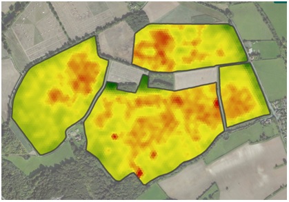
An example of a biomass image:
Seeing the bigger picture
Frontier agronomist, Fergus Hawkins is also finding added value from the service, with the imagery enabling him to give even more precise advice to his growers.
He explains, “Where growers are not using precision application techniques such as yield mapping, the biomass imagery gives us more information than we’d normally have to help with our management of the fields. This is particularly useful when there isn’t an option to variably change application rates.
“Where precision technology is already being used, biomass imagery is a welcome addition for further determining which crop inputs to use and the appropriate levels of those inputs.”
In particular, Fergus relies on the imagery to aid with decisions around growth regulation. One example included the management of oilseed rape: “There was an occasion where we had planned to use growth regulators on several fields of oilseed rape. Due to the effects of varied weather we were actively watching the crops through the biomass imagery and could see that actually, there was no need to apply growth regulators at all.
“While we would likely have come to this decision eventually, the biomass imagery provided us with an accurate field-average reading, something which is really difficult to assess visually and would take a considerable amount of time.”
The imagery is also proving beneficial for assessing potatoes. Areas of low biomass are highlighted and in conjunction with soil nutrient data, Fergus can better see where to dig to look for potential issues such as soil-borne pests, diseases or soil structure issues.
From an agronomy perspective, Fergus believes the added benefits are clear. “In instances where I may not have been to a particular farm for some time, I can use the biomass imagery to get a lot of very accurate information quickly and easily. It’s a great asset for both me and the grower.”
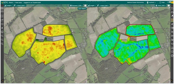
Biomass images can be viewed together with other data layers within MySOYL, from macro-nutrients to soil types and yield maps. Growers will be able to explore such things as how soil type is influencing the current crop’s development, what effects pH or potassium are exhibiting and how the developing crop compares to previous yield maps of the same crop. In fact, the varying scenarios the user can explore are endless. Images can also be used in conjunction with other tool modules within MySOYL.
Tom explains, “Whoever has permission to view a business in MySOYL can access biomass imagery. This facilitates a tool that can be used collaboratively between different advisors on the farm. The farmer can see how crops are developing, while his agronomist can see how the crops they are advising on are progressing.
“This allows for valuable discussion and provides insight into the way the season is moving forward. Whether it is every hectare’s performance that is important, or planning field walks across a whole crop block, MySOYL now provides the information to make more informed decisions.”
Used in conjunction with the field scouting app, iSOYLscout, the new feature provides a crop inspection tool from office to field and back again.
Recording detailed progress
The final dimension of the satellite images is how crops are developing year to year. Many growers may wonder how the same field performed when weather patterns similar to those currently happening last occurred.
Tom explains these benefits: “A grower can see how a crop is developing in the spring, either remotely or in the field. What is more difficult is to make an assessment of how the same field or crop was in previous seasons.
“For example, we have had a particularly long winter this year. By looking at biomass images from a previous or similar season, users will be able to determine how well those performed. This, coupled with the end yield map to quantify those results, gives growers some powerful knowledge and insight to help with decision-making for the present crop. It enables a farmer to change their direction by altering management practices and challenging the advisory team with information on what can and cannot be influenced.”
Having insight into crop variation is also of value when access to the field is hindered by the crop itself (maize or oilseed rape for example).
MySOYL also provides interactive tools for exploring variation. Depending on whether the user is interested in the finer detail or just a simple overview of a crop, there is the choice of enhancing the view on a field-by-field basis.
Image showing the distribution of biomass across a field – focusing particularly on the forward areas of biomass. If this was an early biomass image, this might indicate areas that need holding back or a late season image might indicate areas to push hard for yield:
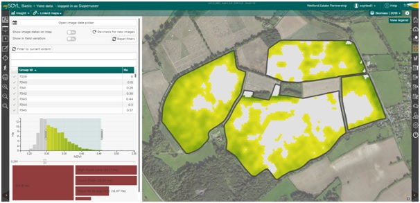
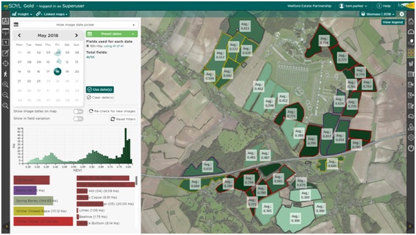
Image showing a much broader view of the whole farm business:
For more information about SOYL’s new biomass imagery technology, contact the team here.