Variable Rate Nitrogen

Log in to MySOYL


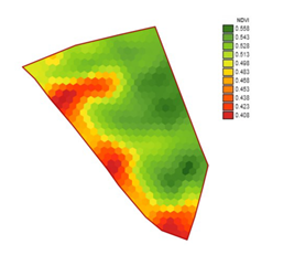
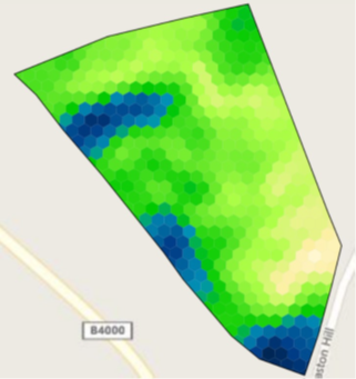
The SOYL Variable Rate Nitrogen (VRN) service uses remote sensing technology to assess crop canopy variation and create targeted nitrogen application plans. Utilising nine satellites and supported by radar imagery, we offer the most comprehensive biomass imagery service available in UK agriculture.


Get started today
Speak to your local representative or email This email address is being protected from spambots. You need JavaScript enabled to view it.

The benefits of VRN

  • An average yield increase of 4.65%
  • Efficient targeting of inputs
  • Consistent and higher grain protein levels
  • More even crop canopy
  • Reduced risk of lodging and disease
  • Increased nitrogen use efficiency (NUE)

What data does the SOYL VRN service provide?


By using nine satellites – understood to be more than any other UK provider - we provide consistent weekly imagery to all our VRN customers to track the progression of their crops and target their nitrogen inputs, even in inclement weather.

Following extensive research and trials we have incorporated radar imagery into our offering. radar imagery is unaffected by cloud cover and provides us with an accurate measurement of crop growth which, when combined with our satellite imagery, ensures we can provide regular cloud-free imagery throughout every application window.


What types of imagery do we provide?


Both NDVI and LAI data is used to create an accurate overview of farm crop performance. The variation in crop canopy is used to assess the crop nitrogen demand at each application and target inputs accordingly to produce a more even, higher quality crop that makes the most efficient use of inputs.


NDVI
Normalised Difference Vegetation Index
NDVIMap
NDVI is an index that is calculated by using satellite imagery to assess the variation in vegetation cover to give an insight into crop health and development.

  • A satellite sensor measures the near-infrared light reflectance of the crop
  • Thicker, healthier vegetation reflects more near-infrared light than thinner vegetation
  • This data is used to rank vegetation across a field
  • The results are displayed as a map.


LAI
Leaf Area Index
LAI
LAI is a measurement that quantifies plant canopies. It’s calculated by assessing the ratio of leaf coverage to ground area. As a rule, the higher the LAI, the better crop yield.

  • NDVI data is calibrated in field to calculate LAI
  • LAI data is used to assess the growth stage of the crop
  • An LAI map offers a more accurate image as it is informed by actual crop conditions in the field.
  • The LAI indicates how much nitrogen a crop needs and has taken up
  • LAI maps allow the use of agronomically led application models based on AHDB research.


Creating a VRN plan from your data

A VRN plan can be created within MySOYL in minutes using the nitrogen tool - ensuring you can make the most of even the smallest application window. This is something you can do yourself through MySOYL or one of our expert team can create the plans for you to your specifications. Our team is on hand to create application maps seven days a week during peak season.

Resources


We have a range of YouTube tutorials available to help you make the most of MySOYL and your VRN plan.


If you would like to discuss any aspect of the SOYL VRN service, please email info@soyl.co.uk or call us on 01635 204 190.

We use cookies to improve our website and your experience when using it. Cookies used for the essential operation of the site have already been set. To find out more about the cookies we use and how to delete them, see our Cookie Policy.

OK